![]() thehs2
thehs2
these web pages
are being produced by
Barry Cornelius

home
London to WestMids
Phase 1
maps
locations
KMLs
WestMids to Crewe
Phase 2a
maps
KMLs
official DfT data
Crewe to MCR
WestMids to Leeds
Phase 2b - 2016
maps
KMLs
official DfT data
Phase 2b - 2013
maps
KMLs
official DfT data
Other web pages
what is the HS2?
links
tweets
contact
privacy
Edgcote and the proposed HS2
The information on this web page was prepared in 2012. It has not been updated since then and so it may no longer be correct.
Below you can see a map from the Ordnance Survey. After a short while, a coloured line will appear superimposed onto it. This line shows the route of the proposed HS2 near to Edgcote. The line should be accurate as it is derived from data for the post consultation route that was published by the Department for Transport in January 2012.
This line is coloured green for green tunnels, red for cuttings, blue for viaducts and yellow for embankments.
As explained below, the route has recently been revised to avoid a Roman Villa. The Roman Villa appears as a red blob on the map. However, it will take some time for this red blob to appear.
how to use the map below on your own web page
Other maps
South Northamptonshire Council have published ten maps showing how the HS2 crosses their region. An extract from the the map that includes Edgcote is given below. If you click on the image and then click again, you can see a larger image.
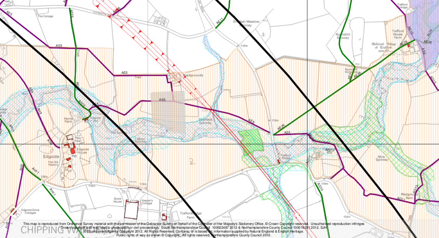
The meaning of the colours and symbols used on this map is
shown below.
If you click on the image, you can see a larger image.

Recent changes to the route
A report entitled Review of possible refinements to the proposed HS2 London to West Midlands Route says: ... the route around Edgcote is of major concern for English Heritage, with the Grade I listed Edgcote House, the scheduled monument Roman Villa site and the approximate area of the Edgcote Moor battlefield which collectively form a cluster of heritage impacts. The consultation route would impact directly on both the battlefield and scheduled monument, and would have setting impacts on Edgcote House and its Park and Gardens.
We have developed an option that would see the route curve eastwards between Aston le Walls and Thorpe Mandeville to pass these features at Edgcote. ... The revised route would avoid the site of the Roman Villa and the likely location of the battlefield, and push the alignment further away from ... Edgcote House Park and Garden. building at risk of demolition.
The Post Consultation Route Engineering report recommends: Following a vertical alignment marginally lower than the Consultation Route, the alignment would cross the River Cherwell floodplain on an 850 metre long viaduct going over several loops in the river. Passing close to the northeast corner of the scheduled monument site at Edgcote, the alignment would pass through a 900 metre section of cutting ... The alignment would result in the loss of agricultural property and buildings at Blackgrounds north of the scheduled monument site at Edgcote.
Jargon
- The consultation route is the route that was proposed prior to public consultation. It was published on 28 February 2011.
- A green tunnel is essentially a deep cutting with a tube put into it, over which grass, trees and soil are placed. It is not as deep as a normal tunnel, and it is much cheaper to construct. This is the definition given on a BBC web page. Here is a link to a photo of a green tunnel.
- The post consultation route is the route that was proposed after the public consultation period. It was published on 10 January 2012.
Credits
The first map on this web page has been generated by www.thehs2.com. The underlying map is provided by OS OpenSpace and this is © Crown copyright and database rights 2012 Ordnance Survey. The generation of the map uses data provided by www.streetmap.co.uk. In order to superimpose an accurate line of the route of the proposed HS2, the map also uses data which was obtained from a shape file provided by the Department for Transport and released with an Open Government Licence.
South Northamptonshire Council have published ten maps showing how the HS2 crosses their region. The second map on this page is an extract from the map covering Danesmoor Spinney to North of Chipping Warden. South Northamptonshire Council say that this map is reproduced from Ordnance Survey material with the permission of the Ordnance Survey on behalf of the Controller of Her Majesty's Stationery Office. © Crown Copyright reserved. South Northamptonshire Council 100022487 2012 and Northamptonshire County Council 100019331 2012. © Environment Agency Copyright 2012. All Rights Reserved. Contains, or is based on, information supplied by Natural England and English Heritage. Public rights of way as shown © Copyright. All rights reserved, Northamptonshire County Council 2010.