![]() thehs2
thehs2
these web pages
are being produced by
Barry Cornelius

home
London to WestMids
Phase 1
maps
locations
KMLs
WestMids to Crewe
Phase 2a
maps
KMLs
official DfT data
Crewe to MCR
WestMids to Leeds
Phase 2b - 2016
maps
KMLs
official DfT data
Phase 2b - 2013
maps
KMLs
official DfT data
Other web pages
what is the HS2?
links
tweets
contact
privacy
Greatworth and the proposed HS2
The information on this web page was prepared in 2012. It has not been updated since then and so it may no longer be correct.
Below you can see a map from the Ordnance Survey. After a short while, a coloured line will appear superimposed onto it. This line shows the route of the proposed HS2 near to Greatworth. The line should be accurate as it is derived from data for the post consultation route that was published by the Department for Transport in January 2012.
This line is coloured green for green tunnels and red for cuttings.
how to use the map below on your own web page
Other maps
South Northamptonshire Council have published ten maps showing how the HS2 crosses their region. An extract from the the map that includes Greatworth is given below. If you click on the image and then click again, you can see a larger image.
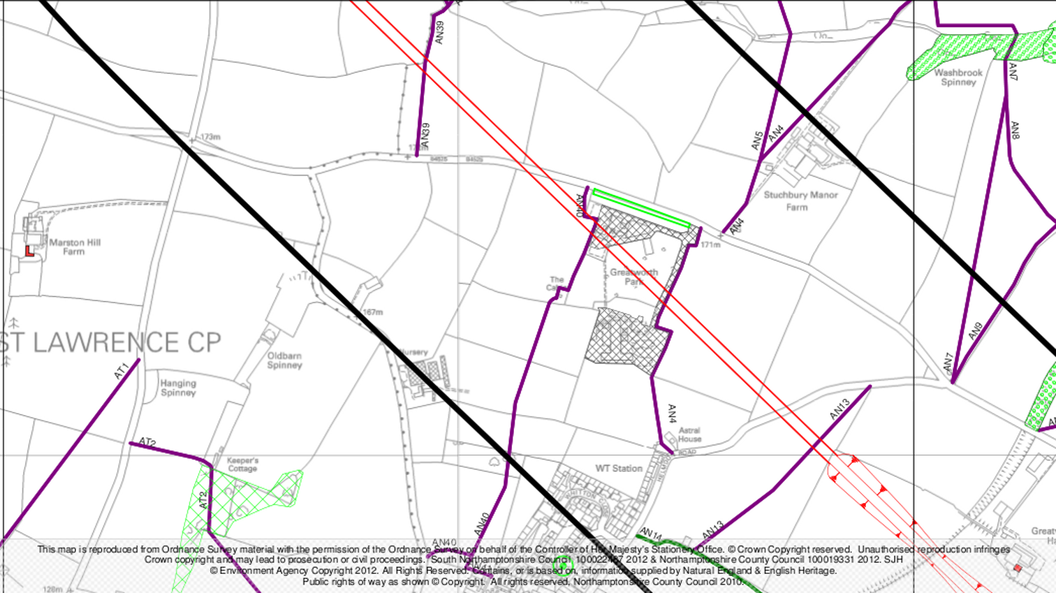
The meaning of the colours and symbols used on this map is
shown below.
If you click on the image, you can see a larger image.

Recent changes to the route
A report entitled Review of possible refinements to the proposed HS2 London to West Midlands Route says: The consultation route would pass Greatworth on an embankment up to six metres high, which would have noise and visual impacts on the village. ... We have looked again at the vertical alignment through this area and have developed a lower alignment including a 1.3 mile (2.1km) green tunnel past Greatworth village. This would remove the need for an embankment and provide an opportunity to reduce excess spoil near Greatworth from the route.
The Post Consultation Route Engineering report notes: In the vicinity of Greatworth the proposed solution for incorporation into the Post Consultation Route is a lowering of the vertical alignment and provision of a 2 kilometre section of green tunnel to the north of the village.
Later, it recommends: Instead of passing Greatworth in open cutting in a similar way to the Consultation Route, the alignment would enter a 2.1 kilometre section of green tunnel, emerging once more about one kilometre northeast of Thorpe Mandeville.
Jargon
- The consultation route is the route that was proposed prior to public consultation. It was published on 28 February 2011.
- A green tunnel is essentially a deep cutting with a tube put into it, over which grass, trees and soil are placed. It is not as deep as a normal tunnel, and it is much cheaper to construct. This is the definition given on a BBC web page. Here is a link to a photo of a green tunnel.
- The post consultation route is the route that was proposed after the public consultation period. It was published on 10 January 2012.
Credits
The first map on this web page has been generated by www.thehs2.com. The underlying map is provided by OS OpenSpace and this is © Crown copyright and database rights 2012 Ordnance Survey. The generation of the map uses data provided by www.streetmap.co.uk. In order to superimpose an accurate line of the route of the proposed HS2, the map also uses data which was obtained from a shape file provided by the Department for Transport and released with an Open Government Licence.
South Northamptonshire Council have published ten maps showing how the HS2 crosses their region. The second map on this page is an extract from the map covering Greatworth to Lower Thorpe. South Northamptonshire Council say that this map is reproduced from Ordnance Survey material with the permission of the Ordnance Survey on behalf of the Controller of Her Majesty's Stationery Office. © Crown Copyright reserved. South Northamptonshire Council 100022487 2012 and Northamptonshire County Council 100019331 2012. © Environment Agency Copyright 2012. All Rights Reserved. Contains, or is based on, information supplied by Natural England and English Heritage. Public rights of way as shown © Copyright. All rights reserved, Northamptonshire County Council 2010.