![]() thehs2
thehs2
these web pages
are being produced by
Barry Cornelius

home
London to WestMids
Phase 1
maps
locations
KMLs
WestMids to Crewe
Phase 2a
maps
KMLs
official DfT data
Crewe to MCR
WestMids to Leeds
Phase 2b - 2016
maps
KMLs
official DfT data
Phase 2b - 2013
maps
KMLs
official DfT data
Other web pages
what is the HS2?
links
tweets
contact
privacy
Old Oak Common and the proposed HS2
The information on this web page was prepared in 2012. It has not been updated since then and so it may no longer be correct.
Below you can see a map from the Ordnance Survey. After a short while, a coloured line will appear superimposed onto it. This line shows the route of the proposed HS2 near to Old Oak Common. The line should be accurate as it is derived from data for the post consultation route that was published by the Department for Transport in January 2012.
This section of the line is coloured black which means the HS2 is in a tunnel.
The plan is to build a station at Old Oak Common.
how to use the map below on your own web page
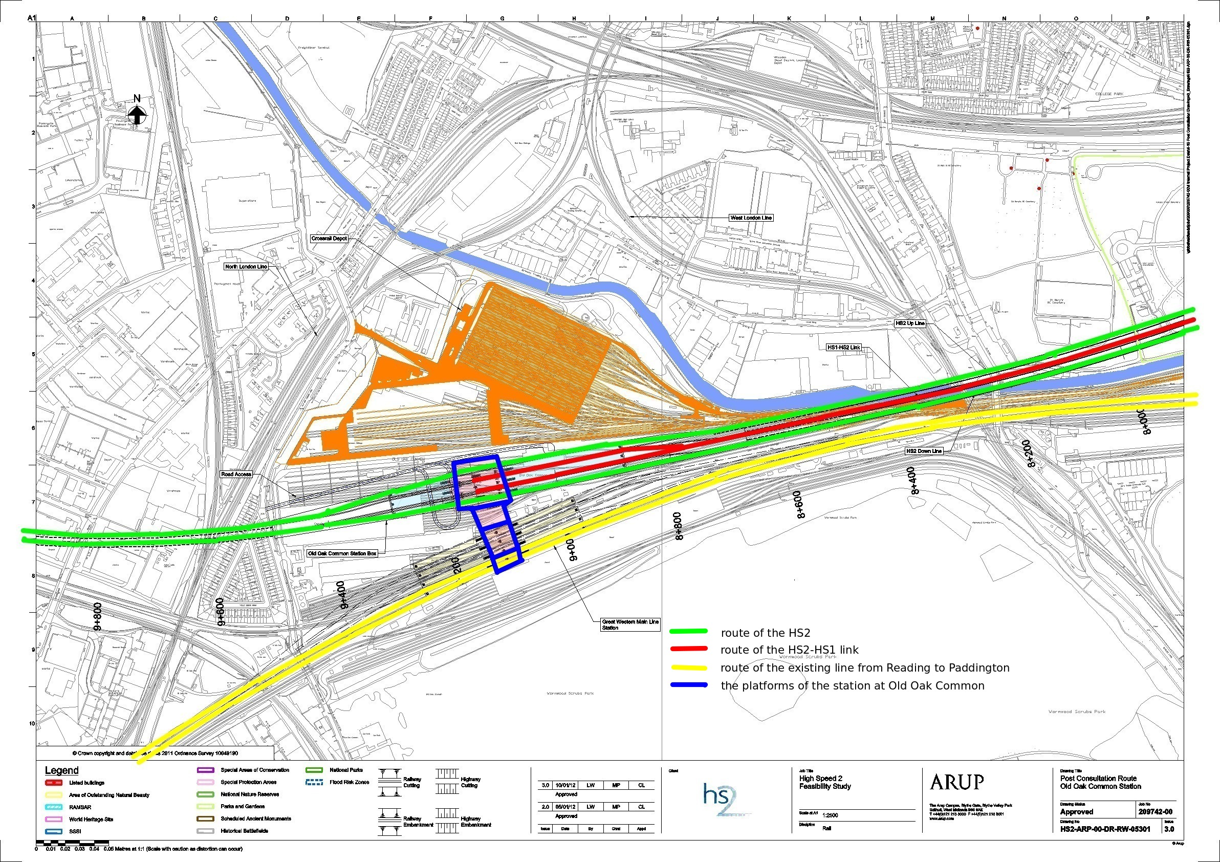
The HS2 London to West Midlands EIA Scope and Methodology Report (LWM‐ARP‐EV‐REP‐000‐00001) says that at Old Oak Common passengers from the West Midlands and North would be able to change onto Crossrail, the Heathrow Express, the Great Western Main Line or other local public transport. There would be a link from Old Oak Common to High Speed 1 (HS1), partially in tunnel and in part along an upgraded section of the North London Line to an existing junction with HS1 just north of St Pancras.
Below there is an image showing a detailed map of Old Oak Common. This time the route is shown in green (rather than in black). If you click on the image and then click again, you can see a larger image.
I've annotated the image with coloured lines. These annotations show my understanding of the intentions. So the annotations may be wrong. Also, the lines I've drawn are likely to be inaccurately placed.
- green: route of the proposed HS2
- red: route of the proposed HS2-HS1 link
- yellow: route of the existing line from Reading to Paddington
- blue: the platforms of the station at Old Oak Common
Credits
The first map on this web page has been generated by www.thehs2.com. The underlying map is provided by OS OpenSpace and this is © Crown copyright and database rights 2012 Ordnance Survey. The generation of the map uses data provided by www.streetmap.co.uk. In order to superimpose an accurate line of the route of the proposed HS2, the map also uses data which was obtained from a shape file provided by the Department for Transport and released with an Open Government Licence.
There's a Department for Transport web site that provides maps of the route. In particular, it provides a PDF that has a map showing Old Oak Common. The second map on this page has been derived from that PDF.