|
This web site provides information about
the High Speed 2 railway line (HS2).
Here is a link to some basic information
about the HS2.
You can keep up-to-date with changes to this web site
by following the twitter feed
@thehs2
or by going to the
tweets web page.
Initially,
the Department for Transport (DfT)
proposed to create the HS2 in two phases: Phase 1 being from London to the West Midlands (including Birmingham)
and Phase 2 taking the line further North.
In 2015, Phase 2 was split into two stages: Phase 2a will be from the West Midlands to Crewe.
And Phase 2b will have two legs: one from Crewe to Manchester and the other from the West Midlands to Leeds and South Yorkshire.
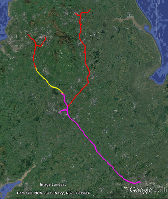
The map on the right uses
magenta for Phase 1,
yellow for Phase 2a,
red for Phase 2b.
- Phase 1: London to Birmingham and the WestMidlands (magenta)
-
The latest version of the route for Phase 1 is the post consultation route
and data for this route was published by the DfT on January 10th 2012.
There's a maps link in the menu on the left that takes you to maps showing this route.
- Phase 2a: WestMidlands to Crewe (yellow)
-
The latest version of the route for Phase 2a is the preferred route
and data for this route was published by the DfT on January 7th 2016.
There's a maps link in the menu on the left that takes you to maps showing this route.
- Phase 2b: Crewe to Manchester, WestMidlands to Leeds and SouthYorkshire (red)
-
Since 2013, there have been three routes for each leg of Phase 2b.
There was the consultation route which was released in 2013,
the preferred route which was released in November 2016
and the confirmed route released in July 2017.
Some of the changes to the route that were suggested in 2016 were relatively small changes whereas 7 were major changes.
In July 2017, the Secretary of State confirmed 6 of the 7 major changes:
the relocation of a depot near Crewe,
the route in the Middlewich-Northwich area,
the approach to Manchester Piccadilly,
the route near East Midlands Airport,
the route in Long Eaton being on a high level viaduct
and
the radical changes to the route near Sheffield (between Bolsover and Normanton).
However, in the Measham area he decided to proceed with
a modified version of the consultation route.
I haven't seen DfT data for the confirmed route (2017).
So for Phase 2b, there are two maps links in the menu on the left:
one to maps for the preferred route (2016) and the other to maps for the consultation route (2013).
For most of the route of Phase 2b, look at the 2016 maps.
However, for Measham the route will be a modified version of that in the 2013 maps.
The best document for seeing more details about the decisions made in July 2017 for Phase 2b is
HS2 Phase 2b Route Decision.
In particular, there's a map on page 35 that shows the differences in the Measham area.
When this web site shows a map displaying the route,
the underlying map can be from OpenStreetMap or Bing.
You can get a web page displaying a map close to a specific place.
And once you've done that there are details about how you could include such a map on your own web page.
You can also display other information on a map such as nature areas and places where footpaths cross the route.
There are KMLs links in the menu on the left that take you to
KML files for
the routes.
|
|
