![]() thehs2
thehs2
these web pages
are being produced by
Barry Cornelius

home
London to WestMids
Phase 1
maps
locations
KMLs
WestMids to Crewe
Phase 2a
maps
KMLs
official DfT data
Crewe to MCR
WestMids to Leeds
Phase 2b - 2016
maps
KMLs
official DfT data
Phase 2b - 2013
maps
KMLs
official DfT data
Other web pages
what is the HS2?
links
tweets
contact
privacy
Charndon and the proposed HS2
The information on this web page was prepared in 2012. It has not been updated since then and so it may no longer be correct.
Below you can see a map from the Ordnance Survey. After a short while, a coloured line will appear superimposed onto it. This line shows the route of the proposed HS2 near to Charndon. The line should be accurate as it is derived from data for the post consultation route that was published by the Department for Transport in January 2012.
This line is coloured red for cuttings, yellow for embankments and fuchsia when it's level with nearby land.
how to use the map below on your own web page
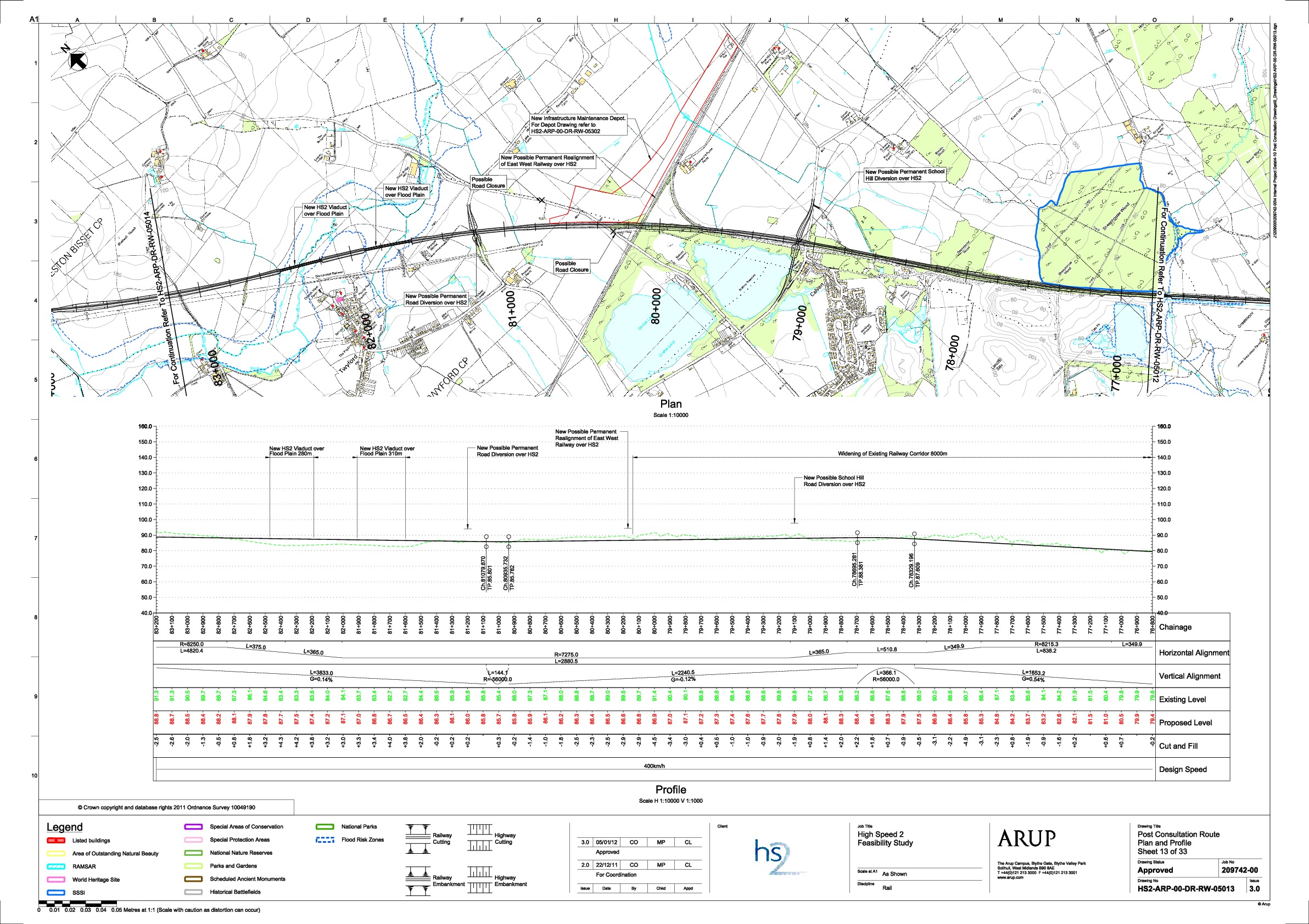
In the middle of the map, the route is in a cutting (coloured red). At this point it intersects with a road. This is the road that proceeds northwards between two lakes and then uses a bridge to cross the Oxford to Bletchley railway line. It is planned to close a section of this road and build the Calvert Infrastructure Maintenance Depot. The western side of the depot straddles the road just north of the bridge and it extends eastwards on the north side of the Oxford to Bletchley railway line as far as the right hand edge of the map.
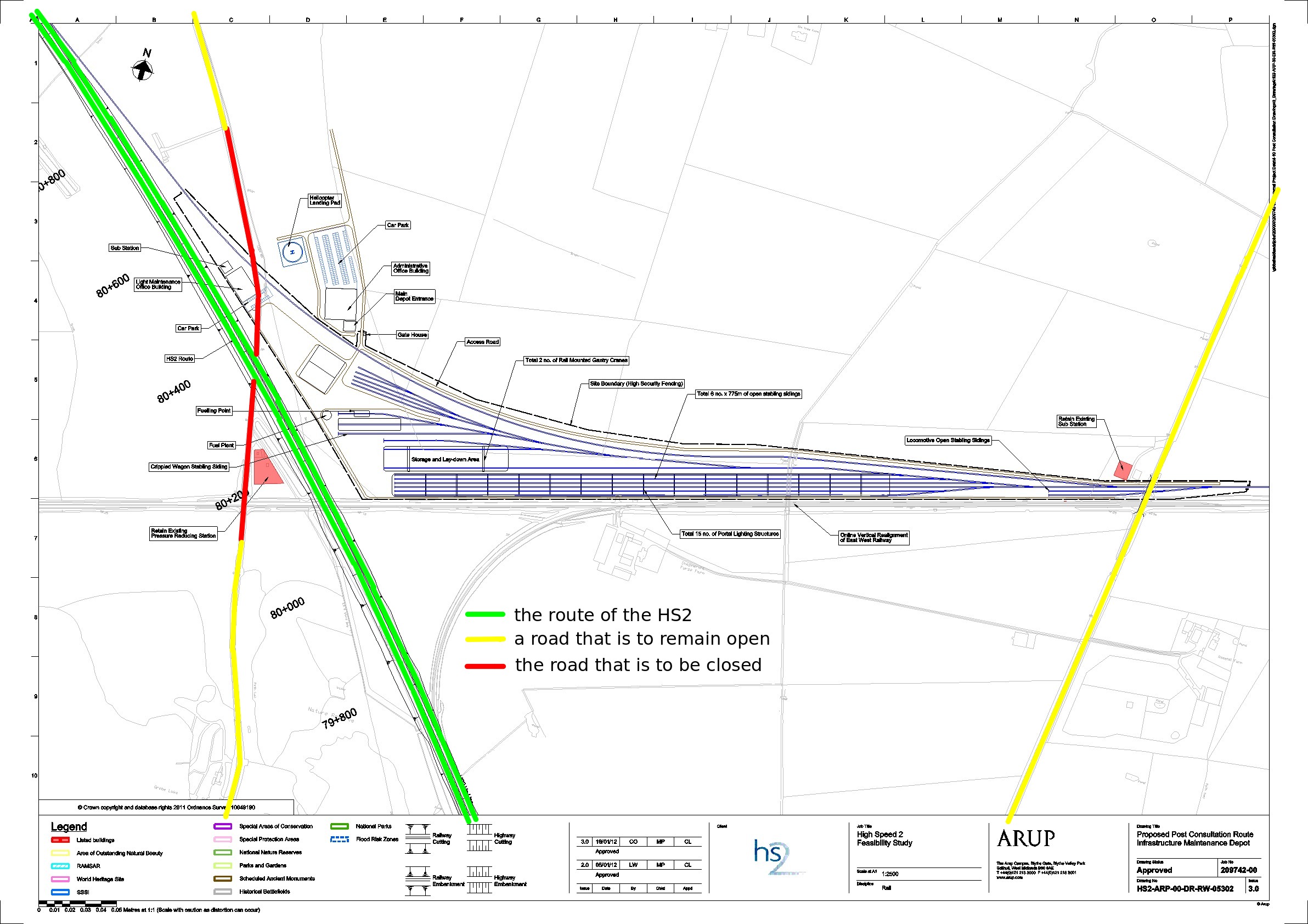
Below there are two images. If you click on an image and then click again, you can see a larger image.
The following image shows a detailed map of the proposed depot. This time the route of the proposed HS2 is shown in green (rather than in a mix of colours).
I've annotated the image with coloured lines. These annotations show my understanding of the intentions. So the annotations may be wrong. Also, the lines I've drawn are likely to be inaccurately placed.
- green: the route of the proposed HS2
- yellow: a road that is to remain open
- red: the road that is to be closed
The following image shows a map of the route from Calvert to Twyford.
Other maps
Here is a link to a map of the area showing the route of the HS2 and the positions of wildlife sites, SSSIs and ancient woodlands.
Credits
The first map on this web page has been generated by www.thehs2.com. The underlying map is provided by OS OpenSpace and this is © Crown copyright and database rights 2012 Ordnance Survey. The generation of the map uses data provided by www.streetmap.co.uk. In order to superimpose an accurate line of the route of the proposed HS2, the map also uses data which was obtained from a shape file provided by the Department for Transport and released with an Open Government Licence.
There's a Department for Transport web site that provides maps of the route. In particular, it provides a PDF that has a map showing the Calvert Infrastructure Maintenance Depot and a PDF showing the route from Calvert to Twyford. The other two maps on this page have been derived from these PDFs.