![]() thehs2
thehs2
these web pages
are being produced by
Barry Cornelius

home
London to WestMids
Phase 1
maps
locations
KMLs
WestMids to Crewe
Phase 2a
maps
KMLs
official DfT data
Crewe to MCR
WestMids to Leeds
Phase 2b - 2016
maps
KMLs
official DfT data
Phase 2b - 2013
maps
KMLs
official DfT data
Other web pages
what is the HS2?
links
tweets
contact
privacy
London Euston and the proposed HS2
The information on this web page was prepared in 2012. It has not been updated since then and so it may no longer be correct.
Below you can see a map from the Ordnance Survey. After a short while, a coloured line will appear superimposed onto it. This line shows the route of the proposed HS2 from London Euston. The line should be accurate as it is derived from data for the post consultation route that was published by the Department for Transport in January 2012.
The magenta section of the line is the platform area; the red section is a cutting; and the black section is a 9K tunnel (that goes a bit further than Old Oak Common).
how to use the map below on your own web page
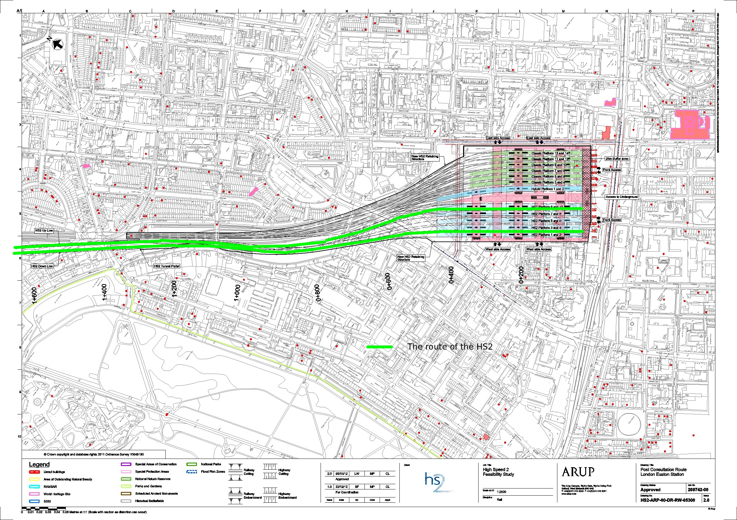
The HS2 London to West Midlands EIA Scope and Methodology Report (LWM‐ARP‐EV‐REP‐000‐00001) says HS2’s London terminus would be an expanded station at Euston. The station would be entirely rebuilt over a single level with 10 platforms for high speed trains alongside 14 classic platforms, two of which would be capable of being used by high speed classic‐compatible services. The station would need to be extended to the south and the west and, to obtain the necessary clearance under Hampstead Road bridge, the platforms would need to be built below the current track level. This would allow new development over the platforms and open up east‐west routes for local people across the site. This would require demolition of property, including around 200 dwellings largely in four mainly local authority‐owned blocks of flats on the Regent’s Park Estate. It would also be necessary to take part of St James’s Gardens and some surrounding buildings.
Below there is an image showing a detailed map of London Euston. This time the route is shown in green (rather than in magenta/red/black). If you click on the image and then click again, you can see a larger image.
I've annotated the image with coloured lines. These annotations show my understanding of the intentions. So the annotations may be wrong. Also, the lines I've drawn are likely to be inaccurately placed.
- green: route of the proposed HS2
Credits
The first map on this web page has been generated by www.thehs2.com. The underlying map is provided by OS OpenSpace and this is © Crown copyright and database rights 2012 Ordnance Survey. The generation of the map uses data provided by www.streetmap.co.uk. In order to superimpose an accurate line of the route of the proposed HS2, the map also uses data which was obtained from a shape file provided by the Department for Transport and released with an Open Government Licence.
There's a Department for Transport web site that provides maps of the route. In particular, it provides a PDF that has a map showing London Euston. The second map on this page has been derived from that PDF.