![]() thehs2
thehs2
these web pages
are being produced by
Barry Cornelius

home
London to WestMids
Phase 1
maps
locations
KMLs
WestMids to Crewe
Phase 2a
maps
KMLs
official DfT data
Crewe to MCR
WestMids to Leeds
Phase 2b - 2016
maps
KMLs
official DfT data
Phase 2b - 2013
maps
KMLs
official DfT data
Other web pages
what is the HS2?
links
tweets
contact
privacy
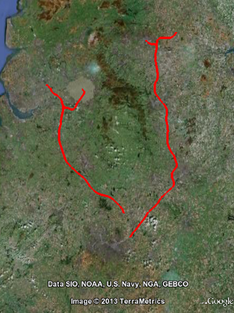
Maps showing the route of Phase 2 of the proposed HS2
|
A Department for Transport web page gives links to maps that provide a detailed depiction of the route of Phase 2 of the proposed HS2. There are links to 73 PDF files that each provide a bit of the initial preferred route at a scale of 1:10000. The aim of this web page is to provide an easy way of finding how close a place comes to the route of Phase 2 of the HS2. Unfortunately, the Department for Transport has not yet provided the data for Phase 2 that makes this easy to do. On January 29th 2013, I submitted a FOI request to obtain this data. Because I don't have this data, the cool ways of doing this that this web site offers for Phase 1 are not available for Phase 2! If you see an ESRI Shape File or a KML file for HS2 Phase 2, please e-mail me. Thanks. So the way that this web site generates maps for Phase 2 is a bit more clunky, but even so I still think it provides an easy way of finding out about the route of Phase 2. To see a map showing how close the consultation route for Phase 2b comes to some place, type into the box below the name of the place (e.g., Middlewich), a postcode (e.g., CW10 9AG) or a grid reference (e.g.,SJ702662, SJ70216629 or SJ7021066291). Then click the search for place button. If you type in the name of a place, you don't have to type in all of the name and the searching doesn't worry about capital letters. So, for example, instead of Middlewich you could type in wich and it would find any place that has wich as part of its name. The name can be that of a town, a village, a farm, an ancient woodland or a SSSI. |
|